Indian Army has released Acceptance of Necessity (AON) for Drones, Reconnaissance systems and Navigation systems
NEWS
The Indian Army released multiple Acceptance of Necessity (AoN) on Monday which Include:
1) Procurement of Upgraded Long Range System
2) Procurement of Runway Independent (RWI) Remotely Piloted Aircraft System
3) Procurement of Inertial Navigation System &
4) Procurement of Mini Remotely Piloted Aircraft System
Upgraded Long Range System
The total Quantity required here is 44, and the category under which the procurement will take place is ‘Buy (Indian)’ in accordance with Chapter-II and Chapter-V of DAP – 2020.
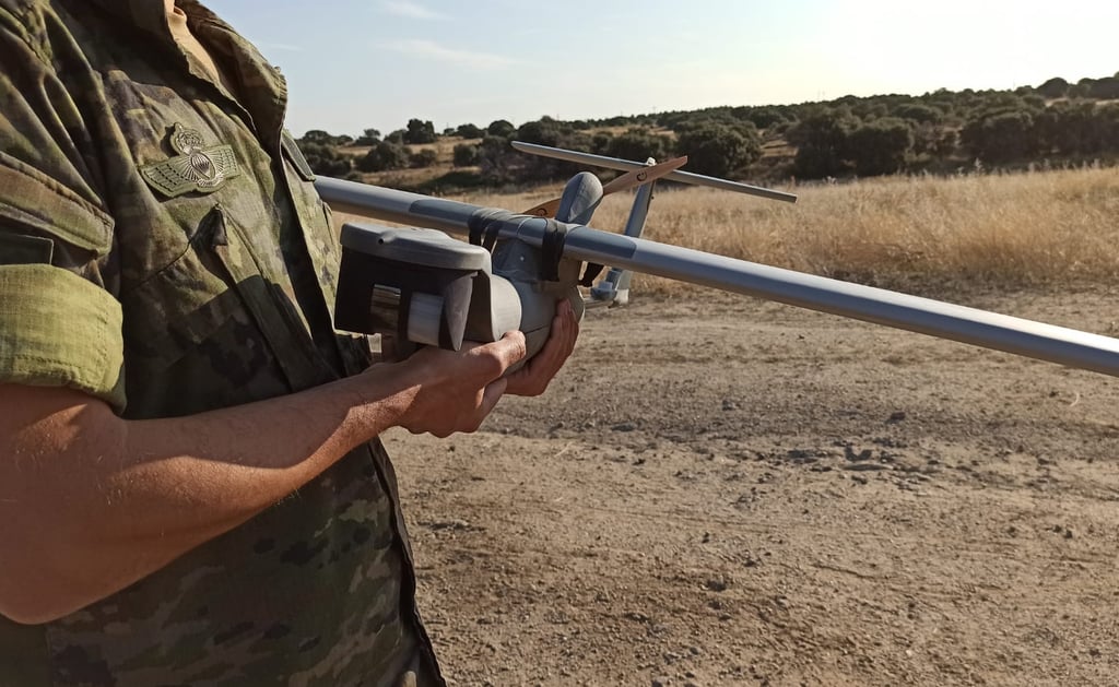
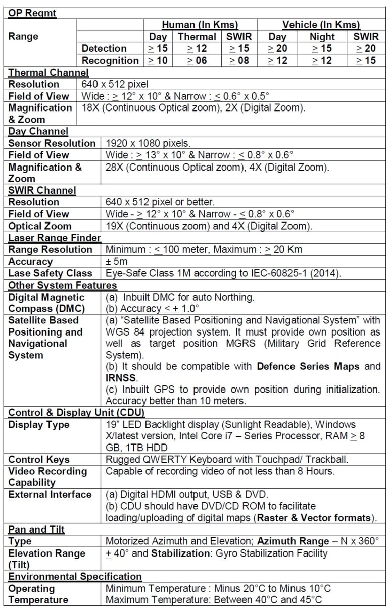
Upgraded Long Range System is a day and night surveillance system mounted on a Pan Tilt Head. The system will be an effective reconnaissance, observation, and surveillance equipment to be employed in various terrains.
System Configuration.
The proposed surveillance system should comprise the following components:-
(a) Day Camera (Colour, Black/White)
(b) Thermal Imager
(c) Short Wave Infra Red (SWIR) Camera
(d) Control Display Unit (CDU)
(e) Laser Range Finder
(f) Tripod
(g) Inbuilt Global Position System
(h) Motion Control System/ Pan and Tilt Unit
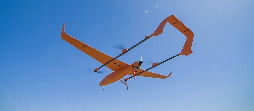
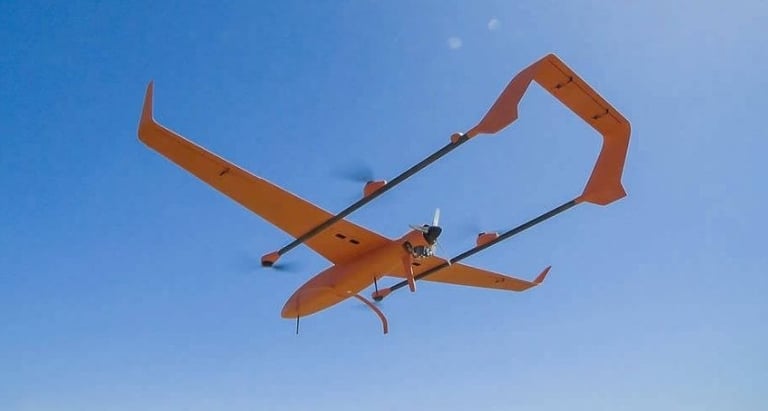
Runway Independent (RWI) Remotely Piloted Aircraft System
The total quantity required here is 10 and the category under which the procurement will take place is Buy (Indian)’ in accordance with Chapter-II and Chapter-V of DAP-2020.
Runway Independent (RWI) Remotely Piloted Aircraft System is ideal for a dynamic sensor-shooter linkage, reducing fixed-wing launch and recovery challenges while freeing troops from stationary runway constraints
System Configuration.
The Tac RPAS (RWI) system should consist of the following subsystems:-
(a) Aerial Vehicle (AV).
(b) Sensor package/ Payloads (Day and Night).
(c) Ground Control Station (GCS) to include power source/generator.
(d) Remote Video Terminals (RVT).
(e) Inter and intra communication system.
(f) Facility to transmit imagery in real time/ near real time to the end user.
Geo Reference: Indian Military Grid Reference should be based on Defence Series Maps (DSM) and the equipment display console should be able to simultaneously read out 10 figure Grid Reference as well as Geographical coordinates in degree-minutes-seconds format.
Launch and Recovery: The RPAS should be capable of Vertical Take Off and Landing (VTOL).
Altitude (With Payload):
(a) Operating Altitude : Upto 4000 M (13000ft) Above Mean Sea Level.
(b) Altitude Ceiling : Upto 5000 M (16000 ft) Above Mean Sea Level.
Endurance: With maximum All Up Weight (AUW) should be 4 hours or more (from takeoff to landing).
Operating Range (At all Operating Altitude): The direct Line of Sight control range from GCS should be minimum 50Km
Speed (for mid fuel weight):
. (a) Maximum Speed : 75 Km/h or more.
(b) Operating Speed : Upto 60 - 120 Km/h.
Navigation System: The system should be compatible with GPS, GLONASS and IRNSS.
Payloads: The system should cater for operation of Electro Optical Payloads:-
(a) Optical Sensor (Day Video Camera, Night Camera, Medium Wave Infra-Red (MWIR) Camera and Laser Range Finder (LRF). The RPAS should have established Gimbal Payload Assembly (GPA) to house the CCD camera (colour) and MWIR.
Ground Control Station (GCS): The GCS should be ruggedized and of modular design and capable of rapid deployment the GCS should be veh based.
Remote Video Terminal (RVT): The RVT should be capable of being remotely located within the communication range of the AV of minimum 20 Km and be tuned to the AV’s downlink frequency. It should be ruggedized portable computer based with a resolution of minimum 1280 x 780 pixels, screen size of ≥ 13 inches.
Data Link Frequency Management: The RPAS should have a suitable uplink and downlink with the GCS in S/C Band (2 GHz to 6 GHz) secured with 256 bit AES encryption or higher standards. The transmission must be digital.
Environment Conditions: The RPAS and payload should be capable of satisfying the environmental requirements as relevant paragraphs of MIL-STD-810 G and JSS-55555. The RPAS should withstand exposure to rainfall rate of 15 mm per hour and wind conditions up to 25 Knots.
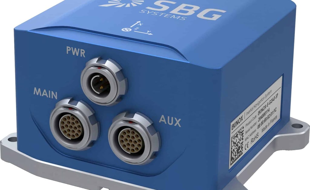
Inertial Navigation System
The Total Quantity required is 106 and the category under which the procurement will take place is ‘Buy (Indian)’ in accordance with Chapter-II and Chapter-V of DAP – 2020.
The broad details in respect of ‘Inertial Navigation System are as under: -
(a) Physical Characteristics. The system should be mounted on a light vehicle and contain GPS, Inertial Measuring Unit, Control and Display Unit, Optical Device for transferring orientation, Laser Range Finder and power supply modules. It should have adequate arrangements to provide shock protection during handling and withstand road and cross country vibrations of the vehicle during operation.
(b) Overall Dimensions and Weight. The equipment should be light vehicle mounted. The overall weight of the system less the vehicle should not exceed 150 kgs
System Performance:
(i) General. The system should provide fixation and orientation information in geographical coordinates and in grid coordinates in UTM grid and in Indian grid system in polyconic and Lambert’s Conical Orthomorphic/ Lamberts conical conformal projections referenced to WGS 84 datum and Everest Spheroid Indian datum as per Indian grid zones. The system should be IRNSS & DSM Compatible.
(ii) Capabilities. The performance capabilities of the system should cover the following parameters:-
(iii) Should have alignment time not more than 5 minutes. (iv) Should have facility for zero velocity update (ZUPT). (v) Should have BITE facility. (vi) Should have the facility for manual feed of known coordinates.
GPS Aided INS: When selected by operator, the system with the aid of GPS should be able to function without the need for vehicle to stop/ZUPT. The system should be able to give the accuracies with/ without the use of differential corrections from DGPS as follows:-
(i) Position (X.Y). 5 m or less.
(ii) Height (Z). 10 m or less.
(iii) Orientation. 10 mil or less.
Stand Alone INS Mode: In the event of GPS signals being spoofed or not received, the operator should be able to cancel the GPS Aided INS mode and select the stand alone INS mode and be able to function purely on INS mode without the aid of DGPS/GPS performing the operations with/without ZUPT.
(i) Open Survey. After initialization, the accuracy should be as follows:-
(aa) Position (X,Y). 5 m CEP or less for distances upto 4 km and 0.15% of total distance travelled or less for distances beyond 4 km.
(ab) Height (Z). 10 m CEP or less for distances upto 10 km and 0.1% of total distance travelled or less for distances beyond 10 km.
(ac) Orientation. Should be less than or equal to 10 mil.
(ii) Close Survey. The system should be able to carry out automatic adjustment of survey data of points already fixed, as and when the survey scheme/mission is closed on to a known point. The accuracy so obtained should be better than the open survey accuracy.

Mini RPAS
The total requirement here is of 80 units, and the procurement will take place under ‘Buy (Indian)’ in accordance with Chapter II & Chapter-V of DAP 2020.
Mini RPAS is a day and night observation system. The system should support conduct of direction of own arty fire. The system will be an effective means of calculating deviation of fall of shot from the target to achieve direction of artillery fire
The broad details in respect of ‘Mini RPAS’ are as under: -
(a) Physical Characteristics
(i) System Components - Each Mini Remotely Piloted Aircraft System for Surveillance and observation of arty fire in High Altitude Areas should consist of not less than following components:-
Two AV per system, 2
Two MPGCS,
Two RVT,
Two day colour video cameras,
Two Monochromatic night thermal sensor,
Two training payload,
One ADR
COTS generator of 1 KVA.
(ii) All Up Weight - Not more than 15 Kg (+10%) but suitable to withstand high altitude strong wind currents/gusts.
Operational Characteristics
(i) Map - Compatible with Defence Series Map and Shape file format.
(ii) Mission Range - Not less than 15 Km.
(iii) Op Altitude - Launch altitude upto 4500m AMSL and gain height of 1500m AGL.
(iv) Endurance - Minimum 90 minutes. Achieve loiter time of minimum 45 minute at 15 km range at 1500m above take off point.
(v) Accuracy - Better than 50m.
(vii) Launch & Recovery - Unprepared area of not more than 50m x 50m
(x) Man Portable - One AV in operational mode to be carried by max two persons
(xi) Flight Mode - Fully Autonomous Mode, Semi Autonomous Mode, Loiter Mode, Target Seeking Mode, Camera Guide Mode, Manual Mode, Return Home Mode.
(xii) Data Link - S/C Band (2 GHz to 6 GHz) with 128 bit AES encryption.
(xiii) Shelf Life - Not less than 500 landings
(xiv) Man Portable Ground Control Station - Capable of calculating target grid correction