Logistic Drones for India’s Northern Borders: Technical Specifications and Requirements
NEWS
3/22/20254 min read
The Indian Ministry of Defence, guided by the Defence Acquisition Procedure 2020 (DAP 2020), has issued two Requests for Information (RFIs) to procure Logistic Drones tailored for medium and high-altitude operations along India’s northern borders. These drones, categorized as Logistic Drone (Medium Altitude) and Logistic Drone (High Altitude), are designed to enhance logistical support in the rugged, mountainous terrains of Jammu & Kashmir, Ladakh, Himachal Pradesh, Uttarakhand, Sikkim, and Arunachal Pradesh. This article delves into the technical parameters and operational requirements outlined in the RFIs, highlighting the specifications that vendors must meet to support the Indian Army’s mission under the "Make in India" and "Atmanirbhar Bharat" initiatives.
Operational Context and Design Philosophy
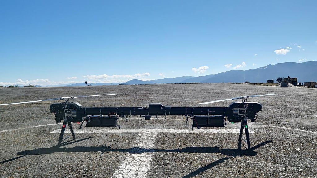
The Logistic Drones are intended to provide an operational logistic surge to forward posts in challenging environments. The Medium Altitude variant targets operations up to 3,000 meters above mean sea level (AMSL), while the High Altitude variant extends this capability to 5,000 meters AMSL. Both drones must operate in mountainous terrain, day and night, under varying weather conditions including dust, and withstand extreme temperatures. The design concept emphasizes modularity, allowing future upgrades without structural changes, and seamless integration of subsystems to maintain performance.
Technical Parameters: A Comparative Overview
The RFIs specify detailed technical requirements under Appendix A, ensuring the drones meet the Indian Army’s operational needs. Below is a breakdown of the key parameters for both variants:
1. Components
Common Requirement: Each drone system comprises one Aerial Vehicle (AV), one Man Portable Ground Control Station (MPGCS), one Remote Video Terminal (RVT), one color day video camera, one monochromatic night thermal sensor, and one set of spare batteries (if applicable).
Purpose: These components ensure comprehensive control, monitoring, and payload delivery capabilities.
2. Payload Weight Carrying Capability
Medium Altitude: Minimum 60 kg, excluding the weight of the color day video camera and night thermal sensor.
High Altitude: Minimum 40 kg, excluding the same optical payloads.
Rationale: The difference reflects the trade-off between altitude and payload capacity, with higher altitudes requiring lighter loads due to reduced air density and power constraints.
3. Operational Altitude
Medium Altitude: Up to 3,000 meters AMSL, with a minimum altitude gain of 500 meters Above Ground Level (AGL).
High Altitude: Up to 5,000 meters AMSL, also with a minimum of 500 meters AGL.
Significance: These specifications ensure the drones can operate effectively over mountainous terrain, reaching forward posts at significant elevations.
4. Operational Temperature
Medium Altitude: -20°C to 50°C.
High Altitude: -35°C to 30°C.
Implication: The broader temperature range for the High Altitude variant accounts for the harsher conditions at greater elevations, demanding robust thermal resilience.
5. Mission Range
Both Variants: Minimum 10 km (one way) with maximum All Up Weight (AUW).
Context: This range ensures coverage of remote posts without requiring intermediate staging points.
6. Endurance
Both Variants: Minimum 60 minutes from takeoff to landing, with maximum takeoff weight (including optical payload) at 10 km range, 500 meters AGL, and their respective maximum AMSL (3,000 m for Medium Altitude, 5,000 m for High Altitude).
Purpose: Ensures sustained flight duration for delivery and return missions in challenging conditions.
7. Navigation
Common Requirement: GNSS-based navigation system supporting NAVSTAR (GPS), GLONASS, and IRNSS (NAVIC), with operator options to select, deselect, or block any GNSS service. Compatibility with Defence Series Map (DSM) parameters and .shp file format is mandatory.
Significance: Multi-constellation support enhances reliability and accuracy, while DSM compatibility aligns with Indian military standards.
8. Launch and Recovery
Common Requirement: Capability to launch and land on an unprepared area not exceeding 10 m x 10 m.
Implication: Facilitates deployment in rugged, unprepared terrains typical of forward posts.
9. Crew
Common Requirement: Maximum two persons.
Purpose: Ensures operational simplicity and reduces logistical footprint.
10. Service Life
Common Requirement: Capable of withstanding at least 1,000 landings.
Rationale: Guarantees durability over repeated missions.
11. Flight Modes
Common Requirement: Fully Autonomous, Manual, and Return Home modes.
Benefit: Offers flexibility for diverse operational scenarios, from automated deliveries to manual overrides.
12. EMI/EMC Compatibility
Common Requirement: Must be EMI/EMC compliant.
Importance: Ensures reliable operation in electromagnetic environments.
13. Geo-References
Common Requirement: Display in Latitude/Longitude or Indian Military Grid Reference (IMGR), user-selectable.
Utility: Supports interoperability with Indian military mapping systems.
14. Simulator
Common Requirement: A simulator for operator training must be provided.
Purpose: Enhances crew proficiency without risking equipment.
Detailed Questionnaire: Vendor Response Expectations
Appendix B of both RFIs outlines an extensive questionnaire to refine these parameters further. Key technical aspects vendors must address include:
Component Breakdown: Weight and dimensions of each component, including carriage/container.
Payload Details: Maximum capacity, securing and release mechanisms, camera/sensor specifications (resolution, field of view, zoom, etc.), and compliance with JSS-5855-11-2019 standards.
Altitude and Range: Highest achievable AMSL and AGL, mission range with maximum AUW.
Endurance: Performance at specified conditions.
Launch/Recovery: Mechanism and exact area required.
Navigation: GNSS compatibility, anti-jamming measures, and geo-reference accuracy.
Environmental Resilience: Limits for wind speed, humidity, visibility, rain, snow, and fog, with test reports from accredited labs.
Flight Modes and Software: Details on autonomy, security (e.g., 256-bit AES encryption), upgradability, and validation per IEEE-12207 and DPIIT standards.
MPGCS: Specifications, portability, ruggedization, and customization options.
Maintenance: Built-in test facilities, avionics upgradability, MTBF/MTTR, and repair philosophy.
Power: Battery or fuel specifics (type, life, charging cycles, availability).
Implications for Vendors
These technical requirements demand a high degree of engineering precision and environmental adaptability. The Medium Altitude drone prioritizes greater payload capacity (60 kg) for operations up to 3,000 meters AMSL, suitable for moderately elevated posts. Conversely, the High Altitude variant, with a reduced payload (40 kg), is engineered for extreme altitudes up to 5,000 meters AMSL and colder temperatures (-35°C), reflecting the severe conditions of high-altitude deployments like Ladakh.
Vendors must demonstrate compliance through rigorous testing, preferably at NABL-accredited labs, and provide detailed performance data for altitudes, endurance, and environmental conditions. The modular design requirement ensures future-proofing, while GNSS and EMI/EMC compliance address operational reliability in contested environments.
Conclusion
The technical specifications for the Logistic Drones (Medium and High Altitude) reflect the Indian Army’s strategic need for robust, versatile unmanned systems to support logistics in its northern frontier. By delineating precise altitude, payload, endurance, and environmental parameters, the RFIs set a high bar for vendors, aligning with India’s push for indigenous defence innovation. As the procurement process advances, these specifications will shape the Service Quality Requirements (SQRs), ensuring the selected drones enhance operational efficiency and resilience in one of the world’s most challenging terrains.